December 20, 2023

Assessing the impacts of climate change on rainfall and infrastructure design criteria
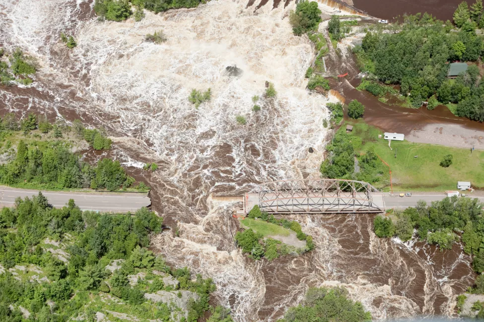
The last decade has delivered numerous catastrophic rain events across the U.S., including a "greater-than-100-year" rain event in Vermont; 1,000-year events in Colorado, South Carolina, and Texas; 500-year rainfall events in northern Wisconsin in July 2016 and June 2018; and Southern California's first tropical storm in 80 years in 2023, breaking records and bringing rare flash floods.
The primary source of precipitation frequency estimates in the U.S. is the National Oceanic and Atmospheric Administration's Atlas 14. Engineers and planners use NOAA Atlas 14 estimates to design and manage much of the nation's infrastructure under federal, state, and local regulations, including mapping Federal Emergency Management Agency floodplains and regulating development in those areas. However, in 2022, the Association of State Floodplain Managers reported that FEMA flood maps fail to account for expected future flood levels, in part because the Atlas 14 precipitation estimates are outdated.
NOAA derives its official rainfall estimates from historical records, which in some states and regions may be decades old, making them insufficient to account for current climate, much less anticipated future weather events. With rainfall events now exceeding historical climate estimates, there is an urgent need to account for the growing frequency of extreme precipitation.
A look inside prevailing precipitation estimates — stationarity and uncertainty
NOAA's Atlas 14 offers infrastructure stakeholders key information on frequency intervals for precipitation events — for example, the amount of rainfall expected to occur in a 24-hour time frame once in a 100-year period in a given location (i.e., a 100-year, 24-hour event). It's also used to produce FEMA's floodplain mapping and support regulating development in floodplains. However, the current atlas presents key challenges related to stationarity and uncertainty.
The 2022 National Weather Service Assessment Report confirms that the NOAA Atlas 14 computes precipitation magnitude and frequency at individual stations based on the concept of climate stationarity — i.e., NOAA's estimates assume that the frequency of extreme precipitation events is not changing over time and that future climate conditions can be represented by past observations.
Both observational records and climate model projections indicate that extreme flood and rainfall events are increasing non-linearly in frequency and magnitude.
The same report notes that there is substantial uncertainty associated with the Atlas's precipitation frequency estimates. Although the published NOAA Atlas 14 values include confidence intervals, they are based on sample variations and do not reflect a changing climate. Additionally, currently published estimates do not consider uncertainty in factors such as parameter estimation, regionalization, interpolation techniques, distribution selection, data quality, and more.
Future rainfall estimates need to consider climate change — Atlas 15 and beyond
Both observational records and climate model projections indicate that extreme flood and rainfall events are increasing non-linearly in frequency and magnitude — conditions not captured by Atlas 14's current estimates.
At the state level, regional planners face a disconnect between the kinds of upgrades a changing climate demands and the data available to them. The emergence of nonstationary climate evaluation is based on the idea that the past is not prologue when it comes to precipitation trends — and that using only historical observations to predict future events is certain to result in underestimating their frequency and magnitude.
To address the challenges of extreme weather events and climate variability, the Flood Level Observation, Operations, and Decisions Support (FLOODS) Act, adopted by Congress in 2022, authorizes NOAA to establish a program to compile, estimate, analyze, and communicate the frequency of precipitation in the U.S. In addition, the Further Continuing Appropriations and Extensions Act, also known as H.R. 1437, adopted in 2022, requires NOAA to develop guidance and take actions to update precipitation estimates, including estimates of probable maximum precipitation.
As a result, NOAA is currently working to develop precipitation frequency estimates for the entire U.S. that account for changing climate conditions. The upcoming NOAA Atlas 15 will consist of two volumes: Volume 1 will account for temporal trends in historical observations and Volume 2 will use future climate model projections to generate adjustment factors. NOAA's current schedule is intended to provide information to support the design of state and local infrastructure nationwide by 2027.

Designing for climate change
From an industry and government planning perspective, extreme weather events heighten risks to valuable infrastructure that's essential to modern life, such as utilities, energy plants, water distribution facilities, bridges, roads, and railways. For stakeholders concerned about maintaining existing infrastructure or planning new designs based on existing precipitation estimates, a custom design review and risk assessment can help provide a critical view of the performance of a structure that might be expected given variable weather conditions.
Depending on the type of structure and potential impacts of its failure — for example, a hospital or dam — builders and engineers may want to consider the impacts of severe scenarios and evaluate infrastructure designs accordingly. Some key questions to include during this process are:
- What opportunities exist to analyze the impacts of climate change on rainfall patterns and flood frequency?
- What alternative methods are available to calculate rainfall and flood frequency?
- What can be learned from reviewing existing state and federal manuals, local flood hazard and risk assessments, and climate change adaptation strategies?
Similarly, in the worst-case scenario of rain- or flood-related damage to infrastructure, project designers will also want to look back and analyze historical data to assess:
- Did the weather event exceed the design condition?
- How do the circumstances and damage affect insurance coverage?
- How can existing infrastructure be modified to avoid future damage?
- How do watershed changes such as development affect downstream flooding, and do these changes exacerbate flood frequency?
Assumptions about the magnitude and frequency of extreme future events will continue to be challenged by climate change. Obtaining clarity on climate-related uncertainties and evaluating designs with a data-driven approach can support public and government entities in driving effective decision-making for infrastructure planning.
What Can We Help You Solve?
Exponent's expert consultants in Environmental & Earth Sciences help clients analyze rainfall patterns, flood frequency, and the impacts of hydro-climate changes on existing and planned infrastructure. We can also help review proposed state and federal manuals, local flood hazard assessments, and climate change adaptation strategies.


![[EECS] Electrical Risk Management - Hazard Analysis - two workers - Damage Assessment Electrical Power Station Analysis Engineer](/sites/default/files/styles/cards_home_card/public/media/images/Damage-Assessment-Electrical_0.png.webp?itok=J9-wZd2_)


